


|
|
| |
Who May Participate?
While the measurement activity may be more appropriate for students in upper elementary through high school grades, students of lower elementary grades could observe how a shadow changes direction and length throughout the day. And by comparing pictures of the mid-day shadow at various locations these students could see, at the least, that where one lives has an effect on the 'behavior' of a shadow during the daylight hours.
Earn a Certificate.
To receive a certificate of participation, be sure to
complete the online data report form.
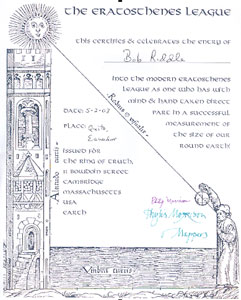
Where Does the Certificate Come From?
The certificate is from an article written by
Brian Poelker, a science teacher at Midwest Central Middle School in Green
Valley, Illinois. All certificates will be mailed from Brian's school as soon as
possible.
Brian is the author of 22 journal articles and
contributor to a dozen science education books and textbooks. He has been long been
an advocate of school collaborative projects and the use of technology. Among
his many awards and acknowledgments Brian was an Illinois delegate to
The Teachers Vision of the Future of Education - A Challenge to the Nation.
As a result of that conference he was a member of the team that presented
"Telecommunications in the Classroom" at the First National Teachers Summit in Miami,
which featured Brian's use of the then infant Internet to link schools in a project
to measure the circumference of the earth.
Poelker, Brian. "Eratosthenes Updated: A Grecian Formula for Measuring
the Earth". 1993, Vol.16, No.6, pp.18-19. Science Scope Magazine.
National Science Teachers Association.
Pin Your Location on the Guest Map.
 Click on this button and please add your location to the Guest Map. Click on this button and please add your location to the Guest Map.
How To Participate?
Download the SunShIP Data Sheet from the Links page. Read over those directions, and make preparations for the project by completing all of the Data Sheet except for what will be determined on the equinox day.
Also read the information about the project on the SunShIP web site.
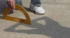
Practice measuring the Sun's altitude using either a shadow stick or a student casting the shadow. (Be sure to use a flat surface and hold the shadow stick as straight up as possible.)
A more accurate measurement can be made by having several teams or individuals measure the Sun's altitude at the same time, and then use the average altitude from those doing that particular measurement.
Just the Facts, Please.
During the equinox day measure the mid-day altitude of the Sun, or as close as you can be to the time of mid-day.
Write this information on the data sheet.
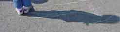
While the measurements are being made take a picture that shows either the person or the shadow stick and their shadow. Follow the directions for labeling and re-sizing the picture, and then e-mail it to the SunShIP e-mail address.
Use the online form to submit the information requested.
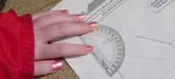
Measure the Sun's Altitude Using the Data Sheet.
Click on this link to see directions for using a shadow stick or pencil to draw a triangle to measure the Sun's altitude.
Primary Grade Students Observe Shadow Changes.
Click on this link to see some directions for having primary grade students observe how their shadow changes during the day.
Measure the Sun's Altitude Using A Student as the 'Stick'.
Click on this link to see directions for using a a student-cast shadow to measure the Sun's altitude.
What Are We Looking For?
We are looking for observational measurement data of the altitude of the mid-day Sun from various latitudes, and pictures of shadows from different latitudes to illustrate how latitude affects the height of the mid-day Sun.
This will be posted on the project web site.
What Is Mid-day?
Mid-day is the time when the Sun is halfway between the time of sunrise and the time of sunset. At this time the Sun will be at its highest above the horizon - its maximum altitude. at mid-day in the northern hemisphere, the Sun is over the southern horizon, while in the southern hemisphere the Sun is over the northern horizon at mid-day.
When is The 2018 Equinox?
Using Universal Time: 20 March - 16:15 UT : 23 September - 01:54 UT.
What Is Universal Time?
Universal Time, UT, is essentially what many of us learned as Greenwich Mean Time. Universal Time is based on the prime Meridian. Your local time and the difference between your local time and UT is based on how many degrees longitude you are from the prime meridian, 0 degrees. West longitude is earlier so you would subtract 1 hour from UT for every time zone west until you reach the International Date Line at 180 degrees West. East longitude is later so you would add 1 hour for each time zone you are east of the prime meridian until you reach the International Date Line.
For example I live in Lee's Summit Missouri at 94 degrees west longitude. Each time zone is 15 degrees wide and represents approximately 1 hour of Earth rotation. By dividing 94 by 15 I find that I am 6 time zones, or 6 hours of Earth rotation, away from the prime meridian. So for my time zone I would subtract six hours from whatever the UT time is difference.
It is easy to convert from UT to either your time zone time, as described above, or convert to your local time based on your longitude . I am an additional 4 degrees west, or 16 minutes of Earth rotation, from the central meridian of 90 degrees for my time zone - Central Time. So I would add an additional 16 minutes to my 5 or 6 hour time difference from universal time.
However, one thing to remember when converting is to allow for being on either Daylight Saving Time, or Standard Time. For me the 6-hour difference is while the United States is observing standard time. However in the United States we 'spring forward' 1 hour when Daylight Saving Time is observed between April and September. This means that the time difference between UT and my local time decreases by 1 hour, to a five hour difference instead of six.
Why Do You Say The September Equinox?
I learned and adopted this expression into personal use from a friend and colleague, Katherine Becker. Although it is the accepted term, Katherine correctly pointed out that it was unfair to the folks in the southern hemisphere for one to say, for example, 'Autumnal Equinox' as it would be the opposite season in the southern hemisphere, spring.
I still use equinox and solstice however they are now prefaced with the name of the month they occur in: March equinox; June Solstice; September equinox; and December solstice. And if I didn't, I would have either Katherine or Eric after me! |
| Global Thinking |
|
 Here are some questions asked by year 5 to 8 students in New Zealand schools. The response to those questions comes from a dear friend, Eric Jackson, a 'Kiwi' educator known for his counterclockwise approach to things. Here are some questions asked by year 5 to 8 students in New Zealand schools. The response to those questions comes from a dear friend, Eric Jackson, a 'Kiwi' educator known for his counterclockwise approach to things.
1. Who decided that the North Pole is at the ‘top’?
It is a Northern Hemisphere misconception that north is at the ‘top’. The Earth is like a sphere. A sphere doesn’t have a ‘top’ nor does the Earth. It is just as correct to put the South Pole at the ‘top’.
2. Why is New Zealand and Australia called ‘down under’?
If south was at the ‘top’ then we are on top and Europe is ‘down under’.
3. Why do clocks go clockwise?
Clocks were invented in the Northern Hemisphere where the Sun goes ‘clockwise’ (left to right) across the sky. If clocks had been invented in the Southern Hemisphere, where the Sun goes from right to left across the sky, clocks would have 9 where 3 is and 3 where 9 is.
4. Why do lots of books show the crescent moon the wrong way around?
Many books printed in the Northern Hemisphere depict the crescent moon as it is seen there which is the opposite in the Southern Hemisphere.
5. Why are the zodiac constellation pictures upside down and at the wrong seasons?
The zodiac is a Northern Hemisphere invention, which does not make sense in the Southern Hemisphere, but there are still some people who believe it.
6. Where do the terms ‘Middle East’ and ‘Far East’ come from?
These terms relate to the Prime Meridian. If the South Pole were at the ‘top’ then our ‘Middle East’ would be the United States and our ‘Far East’, Britain. What is generally understood as the ‘Far East"’ is our Near West.
Eric Jackson says:
Many readers are familiar with time zones but don’t realize that it is from the International Date Line where it all begins to happen. New Zealand, near the International Date Line, is 12 hours ahead of Greenwich time and is half way through a day before UK starts! And what is more, Samoa on the other side of the Date Line, is 23 hours behind New Zealand. This means that the world has to turn twice before every one has the same day. So a ‘day’ is 48 hours long and therefore 8 days must pass before every one has the same week. |
Who is Bob Riddle?
Bob is Adjunct
Faculty for Longview Community College where he teaches online courses in Astronomy.
He is also a Science Consultant for Successlink Science and as such travels around
the state working with science teachers and students in the middle and high school
grades. With more than 25 years of classroom teaching he has taught upper
elementary and middle school Science in traditional, alternative and Academically
Gifted settings, and has served as the Planetarium Director for the Kansas City
Missouri School District. Bob holds a BS Degree in Earth Science from Sul Ross
State University in Texas and an MS Degree in Physical Geography from Illinois
State University.
He is the column editor for Scope on the Skies, a monthly feature of the
NSTA middle school journal, Science Scope magazine, and to date has written more
than 150 columns. He is also the editor of the online Astronomy publication,
‘Que tal in the Current Skies’, a description of celestial events for each month.
He is an active member of the National Science Teachers Association and other
Science Education organizations, having conducted workshops or presentations at
more than 200 regional, national and international conferences. He has been an
outreach educator for several NASA programs including the Solar System Educator
Program, the International Solar Terrestrial Project, and the Solar System
Ambassador Program. In 1999 he was one of about 15 Educators in the United States
selected for the Cassini Fellowship Program by NASA/JPL.
Bob and his wife Sue are empty-nesters living in Lee's Summit Missouri
and share their home with Sebastian, a b/w Shelty, and Chloe the wander cat. |
|
|
|
|